

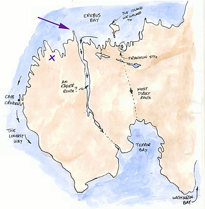
 It rained all night and into the morning. As a result, we got a late start (and a welcome excuse to sleep in). We broke camp at about 11:00 am and hiked all day. (Unimpressed with Derek Smith and John MacDonald's choice of sardines for lunch, John Harrington opted for peanut butter sandwiches.) We walked North West from our camp (approximately at "X" on sketch) to the coast and proceeded to explore every point and inlet along the coast. We hiked for seven hours, a distance of 10 - 12 miles.
The mosquitos are the worst any of us has ever seen. The temperature is about 20 degrees Celsius, sunny and still, and the mosquitos surround us in clouds. Repellant is only partially successful; for the most part we just pull up our hoods and try to keep exposed skin to a minimum.
Although we came across a couple of Inuit tent rings, we did not see any Franklin sites. These tent rings will, of course, be included in the official government report that John MacDonald will file at the end of our trip. Permits are required to do any exploring on the island, and visits must be followed up with reports.
Why are we exploring the western edge of the peninsula? It is generally felt that during the two years Franklin's ships were trapped in the ice several ground parties went ashore to map the area. They would have known of the shortest distance to the south of the island. No one knows for sure which route was taken. We do know they were successful in dragging one of their 28 ft. boats well along the south shore, on Washington Bay. The noticeable cut in the peninsula would be the easiest route to drag a boat, although it was no doubt frozen in May when they moved southwards. A campsite discovery on any of these potential routes would help solve this part of the puzzle. It would at first seem logical for the retreating Franklin party to take the shortest route across the Graham Gore Peninsula. Most everyone assumes this to be the case and, as a result, not much exploration has been done west of the cut.
It is about 7:30 pm. We haven't decided on supper yet, but since it will be daylight for hours there is no rush.
Tomorrow will be a long day; we expect to hike about 20 miles, which will mean 12 hours of hiking. Our goal is to reach Little Point (indicated by arrow on sketch).
 17 18 19 20 2122
23 24
25 26
27 28
29 30
HOMEPAGE
17 18 19 20 2122
23 24
25 26
27 28
29 30
HOMEPAGE