

Webmaster's note: Wednesday morning.
It is now three days since I have heard from the team. Here are the developments so far:
When Fran spoke with Polar Shelf today, they told her that there is a problem with radio communication in the area. They have had difficulty hearing from two other camps as well. They could barely pick up the signals, which were very garbled. They said they had detected some Inuit radio activity, which might have been our guides, but could not verify this. Fran has given them the website information, so they will have the last reported location co-ordinates of the team. Hopefully this will facilitate contact between them. (The arrow near the top of the map points to Resolute, the arrow near the bottom indicates the general area on the Boothia Penninsula where I am assuming the team is located.)
Apparently this problem with radio contact happens quite frequently in the north. We had hoped to overcome this difficulty by having the satellite phone...
Judy (Ron's wife) sent me e-mail to say that she had obtained a fax number for Pat Lyall, and had asked him by fax to contact either herself, Fran or me if he could give us any more information. Then I received a telephone call from Albert Ehaloak, in which he gave me Pat Lyall's phone number. Unfortunately, it turns out that Pat will be away for a few days. I expect to maintain contact with Albert via e-mail for at least minimal information.
As luck would have it, I have been unable to receive e-mail messages from anyone for the past few hours, since now MY server is down! More later.
****************************************************************************************
Wednesday evening:
FINALLY, A REPORT FROM THE TEAM!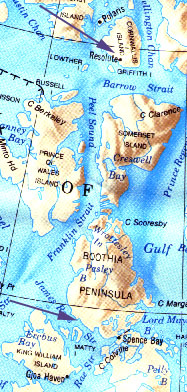 Fran called to say that she had spoken with Polar Shelf. She explained that Polar Shelf is a post in Resolute. Any camps (particularly camps without phones) inform Polar Shelf when they are going "out". From all over the Arctic, camps radio in to Polar Shelf once a day to let them know they are fine. At this time, Polar Shelf also will relay messages to the camps. It's both a message relay service and a security check. If a camp isn't heard from past their check-in time there is a bit of an alarm and they may send out some kind of rescue operation, or get other campers in the near-by viscinity to see if they are safe. (An interesting detail - When John Harrington proposed to Fran a few years ago she was in California and he was on an expedition in the Arctic. The messages were relayed between them via Polar Shelf!)
Hello from Taloyoak! We're picking up more fuel for the boats and some more vegetarian-type food, and we're heading back out. Our phone has been down, so we want to reassure everyone that we're just fine. (W: There was much laughter as I told him, "Wait 'til you read the website!" and he replied, "Oh no! Have the polar bears got us yet?")
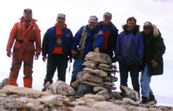 TOMMY, ABEL, RON, JOHN M., DOUG AND JOHN H. AT THE CAIRN WHICH WE BELIEVE TO BE ROSS' CAIRN. 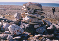 |
First I'll tell you about Monday. Last time we spoke we had just heard from Sam and Leah Tulurialik. Sam had radioed to us that he had found a leather bag near his camp with the date 1847 on it, and human remains were in the area too. Our plan was to go down there. First we revisited Ross' cairn. We had narrowed it down to what we thought was the right one. This appeared to be the oldest of the cairns we had found - judging by the quantity of very thick lichen on it. However, as Doug and John MacDonald pointed out, this may not be indicative of great age because cairns are great perches for birds such as longspurs and buntings and added deposits of droppings can greatly enhance lichen growth. A flat rock hugging the ground can be very old and have little lichen compared to a recent cairn that attracts birds. The cairn had been larger, there were sign of it having been torn down somewhat. If this is, in fact, the location of Ross' cairn, it may have been rebuilt since Ross built it originally. We took lots of photos. Our last phone call out was when I phoned Fran to see if she was able to get the exact modern co-ordinates from Margaret Bertulli in Yellowknife. Margaret didn't have that information. We've got the co-ordinates of the cairn we found in the GPS.
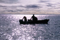
We had to pack up camp. One of the concerns we had was that the ice floes were starting to come in on us from north of King William Island. There's a heavy ice field there, like the one that Franklin's men got stuck in, and it was slowly advancing on us. Last year when the ice came in there was a group trapped here for over a month. There was no way out. If the ice comes up on the land, as it can with a strong wind, it can destroy a boat in short order. We had to get out of there. Since it was coming slowly, we went out into the ice pack just to get some pictures. It was really quite beautiful out there. Our boats were heavily loaded. They are two big boats, so it wasn't a problem, but there were four extra "passengers" - three seals and a caribou! I have some great video footage of the men hunting the bearded seal.
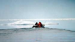 INCOMING ICE FLOES FORCE US TO MOVE. 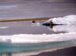 WE CHIPPED ICE FROM THE FLOES TO MELT FOR DRINKING WATER. THERE ARE NO BACTERIA-LADEN GOOSE DROPPINGS ON THIS ICE, AND THE SALT DRAINS DOWN OVER TIME, TO LEAVE IT QUITE POTABLE. |
On our way south, Abel saw his uncle Tony on shore, so we stopped in and had a light lunch with them. It was an interesting area. A lot of people had camped there over the years and there were several graves there that showed signs of cremation. This was a bit unusual. We wondered if some disease had come in there at some time. There was one skull on the surface. There were lots of animal bones in the area. We had to move quicky because the tide was going out, so we headed south again.
At about 5:00 pm we reached Sam and Leah's previous camp. The area is called Haviktalik, which means "Where there is metal". All of our eyebrows went up when we heard that. There's no natural metals in that area. There is copper in the Arctic, but not in this area. We were puzzled as to what the name could mean. Of course, being Franklinites, we wondered if perhaps they came here to salvage some metal items left behind by the crew. Abel said that the people have always talked about a lot of white men dying in this area many years ago. That has our interest as well.
After setting up camp, Doug made a great caribou stew that everyone enjoyed. John even ate the broth.
We were taken to a gravesite that had a wooden casket in it, which is rather unusual. The casket was protruding from the stones. It had rounded nails on it, and appeared to be quite old, maybe early 1900s. There were signs of a camp nearby and an old cabin. All the wood was gone, but there was tarpaper around. That was the exact spot where Sam found this leather pouch. It could be that there were trappers there who had found the pouch somewhere, hopefully nearby, and had brought it back and then left it behind. We haven't seen the pouch yet. We're hoping to catch up with Sam later today and get some pictures of it.
I tried to charge the phone up. It was a day of travel so we only got about three hours of charging. I'm not sure what is wrong. It just doesn't seem to be charging. (W: I suggested that they radio in reports to Polar Shelf, where I could call to get the reports.) We don't have the frequency for Polar Shelf. We have a radio which the guides use, but it doesn't have the Polar Shelf frequency. We are in touch with Taloyoak quite a bit. (W: I suggested that, since Pat was out "on the land", he try to find someone else I could call for reports. He said he would ask Abel and call me back later.)
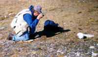 JOHN HARRINGTON PHOTOGRAPHING SKULL 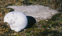 |
On Tuesday we did a systematic search of a point of land near our camp. Every time we check out a point of land I think of a map called the Bayne Map. It was given to one of Charles Hall's compatriots back in 1862. Charles Hall spent time on the Boothia gathering information about the Franklin expedition. He went away for three or four days and while he was away an Inuk came into his camp and gave them some information, namely a map, about where some graves were. Hall dismissed it because he wasn' there when the information came in. The map is basically a point of land. We think it points west, and on the south side were the graves. This is supposed to be a Franklin encampment with graves nearby. Every time I walk a point of land I have this thought in mind.
When we walked this particular point we saw that it does have graves along the south shore. We did find a skull which, to me, looked more like the shape of skulls we found over at Erebus Bay on King William Island. I don't want to get too excited about it because there is a very good chance that I could be misinterpreting it. We're not pretending to be anthropologists. Even John, who has studied this stuff, never jumps to conclusions about these things. He wasn't there when we found it. He was at a different search area and didn't see it. But he's back in camp now, and he will go back there and take a look at it.
We've taken all kinds of photos of the skull from every direction, and lots of video footage. We will share these with Anne Keenleyside when we get back and see what she thinks. (W: For more infromation about Anne Keenleyside, see the 1993 expedition notes.) Of course we didn't move anything. We're very careful about this. We don't even like to touch anything. But we did get lots of pictures.
That's about it for Tuesday's report.
 As for today, the report is pretty thin. We came by boat 58 miles to Taloyoak to get some more fuel and food and hopefully to find a charger for the telephone. No-one in town seems to have one. I'll keep trying to charge it up with the solar panel. This phone is a different model from the one we had before, maybe I've been doing something wrong. (W: I told John about Albert, and how he had contacted Pat and let us know that the team was safe and heading back to Taloyoak because of the ice.) I'll call you back if I can find someone whom you can call to get updates and information. I'll call either way. Give our best to everyone.
(W: John called back an hour or so later, and gave me the telephone number for Daniel and Lucy Tulurialik. If the team cannot reach me by satellite phone tomorrow night, I expect that we will be able to obtain a report from the Tulurialiks.)
Website by Netscapades Inc.
 18
19 20
21 22
23 24
25 26
27 28
29 30
31 HOME
18
19 20
21 22
23 24
25 26
27 28
29 30
31 HOME