The Erebus Bay Expedition
July 7, 1995 to July 30, 1995

TEAM MEMBERS: John Harrington - Team Leader, Business Manager, Artist
Keith Knapp - Historian
Dean Miller - Historian
PURPOSE: To explore the coast southwards from Collinson Inlet and take G.P.S. readings at significant geographic features. Heavy flooding in the area resulted in the team concentrating their efforts in the Erebus Bay area.

Ice floes
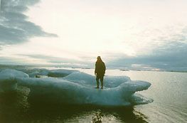
ICE FLOES OF ALL SHAPES AND SIZES
ARE STRANDED WHEN THE TIDE GOES OUT.

SUMMARY: A base camp was set up and daily excursions of 8 to 12 miles were made. Numerous G.P.S. readings were made at significant geographic features. Two Potential Franklin sites were discovered - both were photographed, sketched and G.P.S. readings made. Both sites were left undisturbed. One site had evidence of being a fourth "boat place". The other site appeared to be wreckage from a ship - the only such evidence ever found by any of the teams.
Narwhal tusk
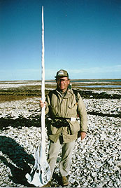
JOHN HARRINGTON WITH PRIZED
NARWHAL TUSK FOUND ON THE
SHORE OF EREBUS BAY.

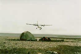
OUR TWIN OTTER ON FINAL APPROACH FOR PICKUP.
GENERAL
WEATHER
CONDITIONS:
  • cold (5 degrees to 10 degrees celsius)
  • heavy fog - dangerous without a G.P.S.
SPONSORS: Canadian Coleman
Canadian Airlines

| 1993 | 1994 | 1995 | 1996 | 1997 | 1998APR | 1998AUG | HISTORICAL OVERVIEW | CANNIBALISM | TENT RINGS | HOME |

Copyright © 2002, Netscapades Inc. All Rights Reserved.
Website by Netscapades Inc.